
Software
|
Software
|
|
|
SHAULA's SOFTWARE APPLICATIONS: OPEN-CPN ( http://opencpn.org ):
OPEN CPN is a chartplotting freeware application, capable to
read a lot of different chart formats, both raster and vector: functionalities
are constantly enhanced, but we have no personal experience to report.
We did not have it at the time of the circumnavigation, we found it only later
and our use has been mostly to review our voyage or to dream about new
adventures. OZI EXPLORER ( http://www.oziexplorer.com ): Ozi explorer is an Australian shareware application that we used in the past to view raster charts: it's well done, but it is not a nautical tool and lacks even basic functionalities which would be found in a dedicated chartplotter.
This Software is interesting for passage planning: all Pilot Chart data for wind and current are used to optimise a route: give it a start and an ending point, and in a matter of seconds the program will give you the optimal route (the fastest or the most comfortable, depending on user's choice). We had it on Shaula3, but truth is we did not use it much, because the few passages where it would have made sense have been already analysed and there are books providing all info on recommended routes, there is little room for a "personal" optimisation! Furthermore, some results provided by the program are odd, it would seem that the sw is overestimating the boat's performance when sailing close-hauled: I wrote to the developers for clarification on the software's calculation method, but they were adamant that it's ok as it is... Funny, but in the end not very useful.
SAILMAIL ( http://www.sailmail.com )
Sailmail is not only an e-mail client, but a full service composed by a number of volunteer-managed radio stations around the world, providing e-mail services to mariners through SSB radio for a nominal fee. The prerequisite to be able to use the service is having an SSB radio equipped with a "Pactor" modem, but the Sailmail software is not limited to connecting via SSB, and it can be used also with wi-fi or dial-up connections like those made available by a sat-phone, so that a single e-mail application can be used no matter how the connection will happen to be. Furthermore, the software is tailored to be used over slow data connections, with a very limited overhead and it even automatically deletes attachments from incoming messages, unless they are GRIB files. In short, the software has its use even on a boat which does
not have SSB, especially for use with a sat-phone. Only
limitation, it can handle only one e-mail account, typically the boat's main
account. OFFSHORE TOOLKIT ( http://www.pangolin.co.nz )
Two of toolkit's components: HF-PROP (a radio-propagation predictor) and the NAUTICAL ALMANAC Pangolin publishes on its web-site a range of useful applications, some free and some shareware: particularly handy the "Nautical Almanac" and the program for astro navigation. Also the radio propagation simulator can be handy to find the
best frequency band to use depending on distance and time of day Shaula's APPs: iSAILOR ( http://isailor.us )
Transas is a firm specialising in big ship's navigation software, so they certainly know their business although they are not a big name in yachting applications. Initially we bought this application, preferring it to better-known names like Imray or Navionics, because at the time it was the only one offering for a reasonable price a world-wide chart coverage which we needed to be able to review our itinerary, while we were not too concerned about the modest functionalities of the chartplotter. The program has been upgraded significantly since then, and is now much better suited for actual navigation purposes; also the chart library has been enlarged, although there are still areas where the detail is inadequate for pilotage. Pity that the latest version ( 1.6 ) is not compatible with our first-edition iPAD, but I think we will get on with it!...
Imray TIDESPLANNER ( http://www.tucabo.com ):
Handy for consultation when not on board, otherwise the same (or better) info is provided by the chartplotter. Furthermore, the data from some mayor hydrographic offices (including the Admiralty) require an yearly fee, which can be very impractical if you are sailing at the edge of the world!...
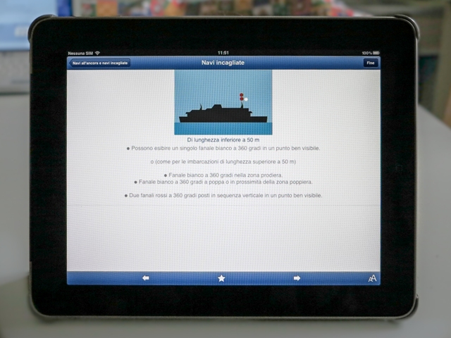
Imray RULE&SIGNALS ( http://www.tucabo.com ):
This App summarizes all that's needed to know under the broad subject of "regulations", such as the Collision (avoidance) Regulations (COLREGS), lights and shapes, acoustic signals, danger signals, buoys, flag signals, use of DSC radio, etc. There is also a "learning" mode, a sort of digital flip-card-like interface where you can check your knowledge of a given situation and then "flip" the screen and check the right answer. Well done and periodically upgraded, it's certainly useful. Pity that in some Countries (like Italy) you must have on board a paper copy of the regulation, which defies the purpose a bit. Several languages supported at the click of a button.
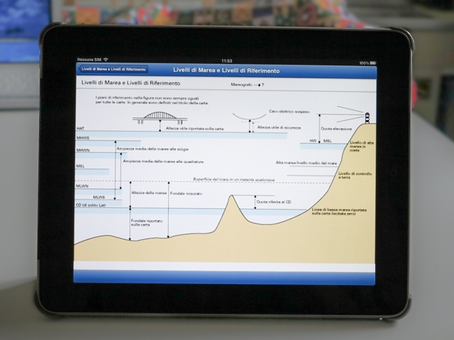
Imray CHARTSYMBOL ( http://www.tucabo.com ):
Basically this is a digital version of the so-called "Chart no.1", which is in fact a booklet containing all symbols used on nautical charts and all relevant conventions, like those related to height and depth reference levels (see picture). Every hydrographic office has its own version, although conventions are rather standardized. Usefull to have on-board, less bulky than the paper version,
although it is quite short on explanation, just the symbols and their meaning.
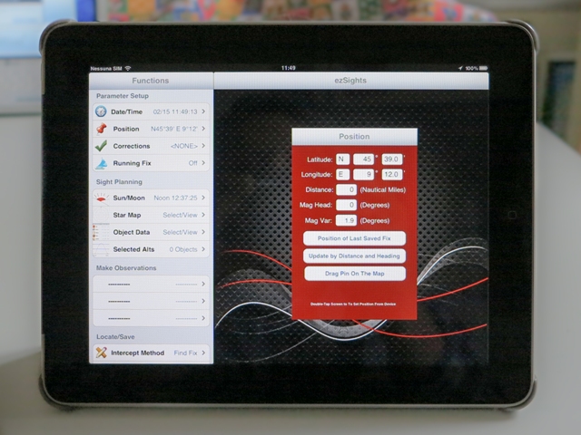
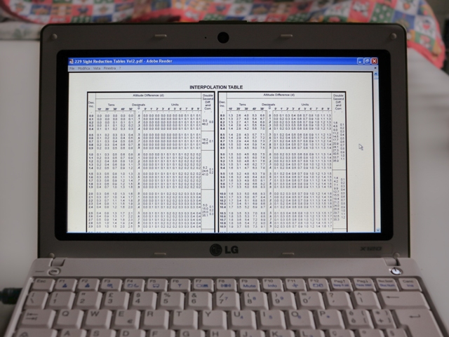
ezSIGHTS:
Having a PC or a Tablet on-board, it seems very obvious having an astro-navigation application installed for use together with a sextant in case of a catastrophic failure of the electronic positioning systems. In reality, this does not make much sense: if ALL electronic positioning systems are out of service, what are the chances that the PC survived the same ordeal and that it will be possible to charge its batteries?! Right, thought so!... Better to be organised to perform astro-navigation in the
less-technological way possible, that is to say pen-and-paper plus paper tables
(maybe stored in a watertight package for protection.
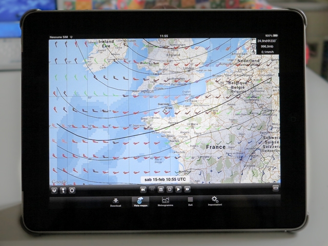
WEATHERFAX HD ( http://www.marineweatherfaxviewer.com ):
Nowadays there is an alternative way to get hold of meteorological charts which are broadcast through the Meteo-Fax service: you can also download them from the Internet! This is one of the many applications that can do that, pity that the list of stations and the list of the specific charts that can be downloaded is just a small portion of what would be desirable, a fact that severely limit this App's usefulness. Meteo charts can be also downloaded with an internet browser from dedicated sites such as "Wetterzentrale" ( http://www.wetterzentrale.de/topkarten/ ).
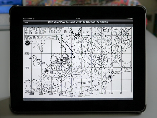
POCKETGRIB ( http://pocketgrib.nickobrennan.com ):
The 21st Century alternative to Meteo Fax is represented by the so-called "GRIB" files, where only the meteo data relative to the points of a grid are broadcast, and it is a task of the viewer program to plot the data over a chart. The big advantage is that the size of the file is very small, even to cover several days at 6-hour intervals, which is very welcome when the internet connection is very slow, like it is usually the case when receiving the data over SSB radio or via sat-phone. GRIB files are available for the whole world, but an important fact must be kept in mind: unlike meteo charts, which are compiled by a meteorologist, GRIB files are the product of very sophisticated weather modelling software applications. Nevertheless, the meteorological community around the world is
devoting a major effort at improving these weather prediction applications, and
their degree of reliability has greatly improved over the last years: during the
round-the-world Rally, most yachts were regularly downloading GRIB files as part
of their daily routine, and we found them to be generally quite trustworthy (at
least offshore, while near land local conditions could still create local
divergence from the general weather pattern). Anyway even in
notoriously problematic areas, such as the Red Sea, we found the information
provided by the GRIB files quite reliable for what concerns wind direction
(useful to know when it was the time to take shelter or when it was time to
weigh anchor and jump forward) while the wind strength was generally
under-estimated by one Beaufort degree or possibly two. APPLE iBOOKS:
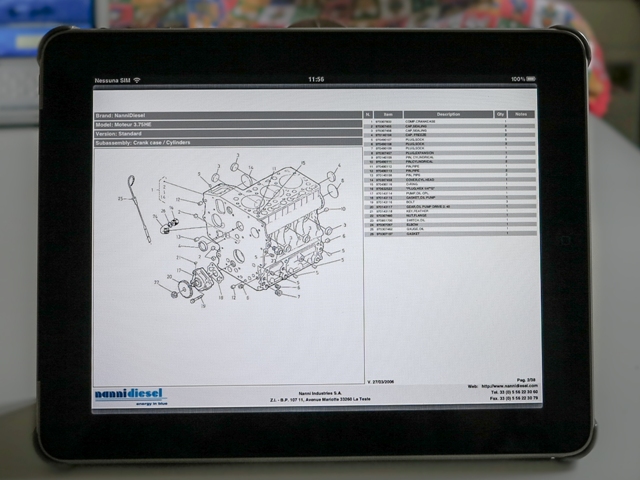
More or less all Tablets are equipped with an application which car read pdf files (a file format very frequently used to distribute publications), such as the iBOOKS App available on the iPAD. Downloading from the internet the pdf copies of all on-board devices is then kid's play: most manufacturers provide these for free on their web-sites (maybe not for out-of-production items) or, in the worst case, making a pdf copy yourselves scanning your paper copy. Some manufacturers, such as Raymarine, even come to the extreme of not providing a paper copy of the manuals anymore, but only an electronic version, and Tablets are very good at serving as e-book readers, especially for documents in colour or containing pictures! We have TWO electronic copies of all our manuals, one stored
on the PC and one on the Tablet.
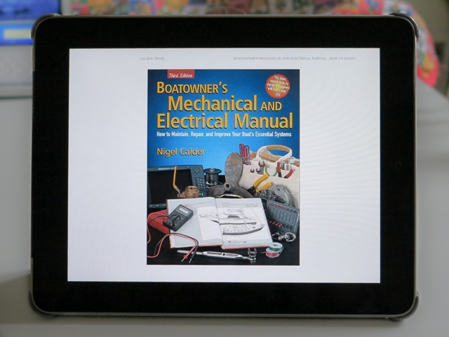
Amazon KINDLE ( http://www.amazon.com ):
Tablets are very good e-book readers, so it comes as no surprise that the Kindle library of our iPAD is full not only with general literature for the lazy moments, but also with many manuals, like the "Boatowner's Mechanical and Electrical Manual" and others, too bulky to carry on a small boat!
|
|
Webmaster: Gianfranco Balducci - email: gfbalduc@tin.it Last Update: 07/09/2017
The
Shaula4 website (text and images) by Gianfranco Balducci is licensed under a |


 This
Imray-distributed App provides tide- and current data mostly for British and
Atlantic-French waters. Unfortunately, very few data points
are available for the Mediterranean, and even less so for the rest of the world,
although there would be plenty of areas were tide and current info would be
useful.
This
Imray-distributed App provides tide- and current data mostly for British and
Atlantic-French waters. Unfortunately, very few data points
are available for the Mediterranean, and even less so for the rest of the world,
although there would be plenty of areas were tide and current info would be
useful.